-
PIETRE GROSSE
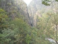
Pietre Grosse is a geosite located on Mount Bo, known for its significant landslide event in the 17th century. The landslide led to the detachment of large boulders, which now characterize the rugged terrain.
-
Alpe Stofful
The place is strongly linked to the Walser culture as there were active quarries for the extraction and processing of soapstone. Soapstone has been mined since time immemorial on the slopes of the Corni di Stofful in Alagna. The main quarry is located NE of the Stofful Superiore alp. There once existed an evident although not deep excavation, which was buried in the last century by a landslide; currently there is an open-air quarry on the site, occasionally visited by local tourists
-
Chenaillet Lava Pillow
At the Colletto Verde, on the border between Italy and France in the Montgenevre sector, there is an outcrop of basaltic lavas, rare evidence of an ocean floor 160 million years old. The western side of the outcrop, a 80 meters high wall, is divided into subspherical sized structures between 0.5 and 1 meter or more ellipsoidal shapes stretched and flattened. The scientific term "pillow lavas" derives from their characteristic shape similar to large pillows or bubbles. The choice of this geosite is motivated by the relevance petrographic-mineralogical importance that these structures are found in the Alpine arc.
-
 Casletto bridge
 Outerop of "Cenerigneiss", rocks that derive from the metamorphism of a sedimentary rock, probably from a conglomerate, originating from a submarine landslide along an active continental margin.
-
 Casletto bridge
 Outerop of "Cenerigneiss", rocks that derive from the metamorphism of a sedimentary rock, probably from a conglomerate, originating from a submarine landslide along an active continental margin.
-
Bobrowe Skały (Beavers Rock) GEOSITE
The site represents a wide, latitudinal belt of orthogneisses belonging to the Jizera Metamorphic. It is located between the Szklarska Poręba shale belt in the south and the Kamienica shale belt in the north. The main core of Bobrowe Skały is built of porphyry granites, in which large "holes" form a microcline, and the fine-grained spaces between them are made of plagioclase, quartz, biotite and muscovite. These granites occur among occluded-layered gneisses. The gradual transitions between these rocks are the result of tectonic deformation taking place at temperatures of about 300 degrees Celsius at depths of up to 5 km, which took place in the Lower Carboniferous (350–330 million years ago), i.e. during the Variscan movement
-
Skałka Teściowej (Mother In-Law's Rock) GEOSITE
The Mother-in-law's Rock is composed of typical hornfels belonging to the granite cover of the Karkonosze pluton. They were created as a result of the impact of granites on the slates of the Szklarska Poręba range. Contact with the granites runs approximately 400 m to the south. These are gray and dark gray rocks with a characteristic lumpy structure and clearly visible orientation of minerals. The mineral composition includes quartz, biotite, chlorite and typical contact minerals: cordierite and andalusite, which intertwine with quartz to form characteristic lumps on the rock surface.
-
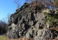
Krucze Skały (Raven Rock) GEOSITE
A rock group composed of typical Karkonosze granites (Karkonosze pluton), gray and grey-pink in color, with a chaotic rock background texture and a large variation in the size of mineral grains. The lower part of the rocks is made of light, even-grained granite, while the top is made of porphyry granite. In granites, especially porphyry varieties, wavy biotite streaks appear. Next to the szlires, there are numerous, spherical or oval enclaves with a dark color. Aplitic veins are visible in the lower parts. Throughout the entire rock group, a characteristic system of cracks with a NNW-SSE direction is visible.
-
Montorfano GEOSITE
In the southern and eastern part of the Sesia Val Grande UNESCO global Geopark territory there are bodies of granites that intruded the Hercynian basement of the South Alpine Domain during the late Vasiscan phase. The age of the rock is estimated around 282 My. From some of these bodies are extracted ornamental stones, for example the white granite called “Bianco di Montorfano”.
-
Prato Sesia GEOSITE
Walking on the outcrop, one can distinguish rocky blocks of different colours, enveloped in a pinkish-yellow tufa; here and there we find reddish
rocks, glassy rhyolites, grey andesites or tuffs rich in rock fragments (Figs. 2 and 3). It is a kind of sampler of the rocks that had formed on the surface during volcanic activity, before the final act: the catastrophic eruption of the Sesia supervolcano some 282 million years ago.
It is estimated that more than 500 km3 of ash and lapilli were erupted in a very short time; at the same time, the entire volcanic apparatus collapsed and huge blocks collapsed into the caldera that had formed, a chasm at least 13 km in diameter. Much of the erupted material fell back into the caldera, mixing with the blocks and forming the chaotic set of rocks we have under our feet: the mega-breccia (Fig 4). Among the fragments forming it, it is even possible to find pieces of the ancient continental crust, also shattered by the explosion, such as the so-called Lake Shale, rocks recognisable by their silvery glow and characteristic foliation (Fig 5).
After the gigantic eruption, the activity of the magmatic system stopped, but many other geological events followed.
We could talk about when the sea arrived or how the mountains were formed: other beautiful stories that our Planet whispers to us. Stories that geologists are ready to listen to, to reveal to those who have never heard them.
-
Vocca Island
We are in the deepest levels of the Basal Complex: it formed between 290 and 282 million years ago in the deepest part of the crust, thanks to continuous injections of magma from the mantle below.
During its slow cooling, the complex consisted partly of crystals that had already solidified and partly of material that was still molten: we could imagine it as a kind of gigantic 'boiling slush'. The resulting rocks outcropping here are gabbros, characterised by light and dark bands depending on the prevalence of two minerals: plagioclase, white, and pyroxene, black (Fig 1). A large dark boulder emerging from the river shows an area of accumulation of the black minerals: the rock forming it is an olivine pyroxenite (Fig. 2).
Here and there on the outcrop one can also see gabbros with traces of deformation that occurred at high temperature (Fig. 3).
The magmas that formed these rocks reached temperatures of over 1200°C: it was the large amount of heat given off by this enormous intrusion that triggered the extraordinary activity of the Sesia supervolcano.
If we take a closer look at the gabbros, we observe an obvious foliated structure: the constituent minerals are elongated and displaced in the same direction.
-
Castellazzo GEOSITE
It is a large sub-rounded rocky block that lies on the grassy clearing enclosed by the ruins of the medieval 'Castrum Capriarum', on the top of a rocky hump that emerges some twenty metres from the alluvial plain of the Dora Riparia, on the border between the municipalities of Condove and Caprie in the Castellazzo region (Susa Valley). There are several aspects of interest that this geosite site presents: the multiplicity of shapes linked to the modelling of the ancient Quaternary glacier of the Susa Valley; the historical monumental context; the surreal landscape value of a rocky island miraculously preserved from the siege of anthropic activities and infrastructures with a strong environmental impact (quarries, motorway, power lines). The rocky block in the Castellazzo region is a typical example of an erratic boulder, i.e. a large stone element that fell by landslide onto the surface of a glacier and was transported by it further downstream, even over distances of kilometres (diagram 1).
Only with this mechanism is it possible to justify the presence of a rock block of a different lithological nature (metagranite) from that of the base and the adjacent slope, which consist of serpentinitic rocks.
On the basis of the distribution of lithotypes with a mineralogical composition similar to that of the boulder, and the considerable degree of rounding of the erratic boulder, it can be hypothesised that the most probable area of origin of the boulder itself is on the southern slopes of Mount Baraccone behind the present-day Borgone village.
The installation of the erratic boulder on the top of the mound in the Castellazzo region, and of numerous other boulders on the left slope in the Truc le Mura locality, took place at the time of the disappearance of the glacial mass that covered the Castellazzo mound (diagram 2).
-
Rocca Furà GEOSITE
No less important in the Borgone area was the cultivation of softer levels rich in lamellar minerals (mica) for the production of millstones (or grindstones). This singular activity came to an end before the 20th century and was mainly concentrated in correspondence with a rocky buttress not far from the Chiampano settlement, called 'Roccafurà'; a local term evocative of the large fissure opened in the belly of the mountain. Exploitation took place at the expense of lenticular bodies of silvery micaschists** (1) embedded in metagranite (2) and strongly deformed, with thicknesses varying from a few decimeters to a few metres.
-
Cava Chiampano GEOSITE
quarries on the mountain ridges of the left slope provided blocks of valuable material from which skilled stonemasons ('picapere') extracted lintels, windowsills, columns, capitals, and ashlars used for monuments, palaces, bridges, etc.
This flourishing activity ceased in the 1970s with the closure of the large Chiampano quarry, which has now been transformed into a popular rock gymnasium exploiting roofs and ledges developed in the schistosity planes and fracturing systems.
-
Borgone Roches Moutonèe GEOSITE
The rocky buttresses that rise in steps behind the town of Borgone represent one of the best-preserved examples of the powerful modelling and smoothing action exerted by the great quaternary glacier of the Susa Valley.
These spurs present a markedly rounded top, with the flanks south-facing sides steep and smooth, while those exposed to the north connect to fertile plateaus, often elongated according to the direction of the valley axis.
Remaining intact for thousands of years, this evidence of glacial modelling has been eroded in several places by the opening of quarries for the exploitation of the valuable Borgone meta granite. The mining activity, carried out intensively for centuries, has given the landscape a new architecture not without its own interesting features.
Borgone's metagranite has long been a primary source of wealth for the local economy. The open quarries on the mountain ridges of the left slope provided blocks of valuable material from which skilled stonemasons ('picapere') extracted lintels, windowsills, columns, capitals, and ashlars used for monuments, palaces, bridges, etc.
This flourishing activity ceased in the 1970s with the closure of the large Chiampano quarry, which has now been transformed into a popular rock gymnasium exploiting roofs and ledges developed in the schistosity planes and fracturing systems.
No less important in the Borgone area was the cultivation of softer levels rich in lamellar minerals (mica) for the production of millstones (or grindstones). This singular activity came to an end before the 20th century and was mainly concentrated in correspondence with a rocky buttress not far from the Chiampano settlement, called 'Roccafurà'; a local term evocative of the large fissure opened in the belly of the mountain. Exploitation took place at the expense of lenticular bodies of silvery micaschists embedded in metagranite and strongly deformed, with thicknesses varying from a few decimeters to a few metres.
-
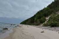 Miedzyzdroje-Wiselka Cliff GEOSITE
 These cliffs stretch for about 11 km east of Międzyzdroje. They constitute the northern edge of the moraine and kame hills of the Woliński Range, formed by the receding ice sheet of the Pomeranian phase of the Baltic glaciation (the Vistula glaciation, northern Poland). These are the highest cliffs in Poland. Mount Gosań, which is also the highest point of the Polish coast, is nearly 95 m above sea level. around Grodno and further towards Wisełka. The average slope of the cliff slopes in this section is about 50 degrees. Two levels of boulder clays (moraine) can be observed in the cliff profile: the lower one, gray in color, up to 40 m thick, associated with the Warta glaciation (Middle Polish, approx. 210,000 years ago) and the upper - younger, yellow-brown in color, up to 3 m thick, associated with the youngest thrust of the ice sheet on this area (Vistula glaciation, North Polish, Pomeranian phase of the glaciation Baltic, 14-12 thousand years ago). They are covered with a series of fluvioglacial (fluvioglacial) sandy and gravel formations of varying thickness, and a series of aeolian sands (2-15 m) on its surface. Just above the beach level, there is a burst of gray marls of the Cretaceous period, i.e. a large block of rock cut from the ground by the ice sheet, displaced for a certain distance and deposited within the post-glacial sediments. There are numerous marcasite concretions (assemblies). On the cliff, apart from analyzing the geological structure, you can observe contemporary sculptural processes shaping the seashore. The cliff in this section is a "living" cliff (active, active), and therefore subject to the influence of sea waves, wind and constant changes. In many places it creates an almost vertical edge with a distinct abrasion niche (edge undercut) at the base. Cliff shores can be divided into: landslide-runoff type (in the zone where sands, gravels and inter-moraine silts with groundwater exudation occur between the level of compact boulder clays), fall-off type (on slopes built mainly of compact boulder clay) and scree type ( composed largely of thick series of fluvioglacial sand and gravel sediments devoid of groundwater). All the above-mentioned types of cliffs can be observed in the Międzyzdroje-Wisełka section. In this cliff, in its sandy and gravel part, there are mostly landslides. In places where there are sands or gravels in the substrate, this material loses its compactness after drying and begins to crumble under the influence of gravity, creating characteristic heap cones. The "tongues" of sand slide systematically and continuously, although with different frequency and speed, their shape also changes. With a steeply sloping slope, vegetation cannot settle the moving and constantly sliding sand. Extensive sandy cones often mask the structure of the cliff in the lower parts. On the other hand, when the substrate is very moist, slides, landslides or runoff of the plasticized clay mass are formed. Very wet formations (dust, clay, and even fine-grained sands) then begin to flow down the slope, creating long, muddy "tongues", flowing often across the beach to the sea. Their color, depending on the content of clay or dust, is usually gray or brown. When the aquifer is exposed, water seeps constantly. The most characteristic of boulder clays are the falls of large blocks. They are often caused by various climatic factors, most often rains and frosts, as well as by "undercutting" by sea waves. Abrasion, i.e. the destruction and retreat of the cliff, causes that it has an almost vertical profile in many places along this section. As a result of landslides and landslides, characteristic "steps" are formed, and often whole undisturbed patches of grassy grasslands, thickets and even clumps of trees fall down. When the aquifer is exposed, water seeps constantly. The most characteristic of boulder clays are the falls of large blocks. They are often caused by various climatic factors, most often rains and frosts, as well as by "undercutting" by sea waves. Abrasion, i.e. the destruction and retreat of the cliff, causes that it has an almost vertical profile in many places along this section. As a result of landslides and landslides, characteristic "steps" are formed, and often whole undisturbed patches of grassy grasslands, thickets and even clumps of trees fall down. When the aquifer is exposed, water seeps constantly. The most characteristic of boulder clays are the falls of large blocks. They are often caused by various climatic factors, most often rains and frosts, as well as by "undercutting" by sea waves. Abrasion, i.e. the destruction and retreat of the cliff, causes that it has an almost vertical profile in many places along this section. As a result of landslides and landslides, characteristic "steps" are formed, and often whole undisturbed patches of grassy grasslands, thickets and even clumps of trees fall down. means the destruction and retreat of the cliff, causes that it has in many places on this section an almost vertical profile. As a result of landslides and landslides, characteristic "steps" are formed, and often whole undisturbed patches of grassy grasslands, thickets and even clumps of trees fall down. means the destruction and retreat of the cliff, causes that it has in many places on this section an almost vertical profile. As a result of landslides and landslides, characteristic "steps" are formed, and often whole undisturbed patches of grassy grasslands, thickets and even clumps of trees fall down
-
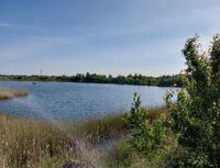
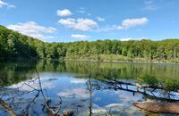 Kociolek lake
 An oval lake, with steep boundaries. Despite the small area (4,2 Ha), it is quite deep (7,5 m). It is origniated by subglacial circulation of water, which excavated the sediments under the glacier
-
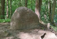 Erratic boulder prof. Wodziczki GEOSITE
 The rock is the lead eratic - Jaereda granite from an outcrop in Smaland in the south-east. Sweden
-
Bukowsko-Mosiński Esker GEOSITE
The escarpment is made of sand and gravel, sometimes covered with a thin layer of moraine clay, which indicates that this form was created in a subglacial tunnel. The areas adjacent to the esker are, in some places, filled with lake sediments (peats, gyttja). This situation, the appearance of the forms and the accessibility make it an attractive object in many respects.
-
 Krosno gravel pit geosite (1530)
 The Krosno site is located within the latitudinally oriented Obra Proglacial Valley. It is located in the N part of the proglacial valley - 500 m to the N the edge of the upland rises. Within the 50 m by 80 m gravel pit, below the water table, there is a significant accumulation of fossil faunal remains from the Late Glacial and Holocene in sandy and gravelly fluvial-glacial and fluvial deposits. Remains of a mammoth, a woolly rhinoceros and bird bones can be found in this pit.
-
Bottaccione Gorge Geosite
The section is a global reference succession for bio-and magnetostratigraphy across the Cretaceous and Paleogene, including the K-Pg boundary. Here pelagic limestones were first dated with foraminifera in thin section, long-section magnetic polarity-reversal stratigraphy was first established, and the K-Pg iridium anomaly first detected.
-
 Zakręt Śmierci GEOSITE
 It occurs exposedly within the rocks of the Karkonosze-Izera massif. The rocks near the road show a sharp, unconforming contact between the granites of the Karkonosze Pluton and the rocks of the Jizera Metamorphic, changed by the thermal influence of the granites (700–750°C). The cover rocks are represented by hornfels composed of quartz, feldspar, biotite, andalusite, cordierite with the participation of magnetite, corundum and tourmaline. We observe the interlocking of dark gray hornfels with granites, as well as small veins of light, fine-grained aplites. The contact is intrusive, in places within the granites there are irregular hornfels blocks of various sizes (up to 20-30 cm), often with quartz pockets, the so-called intrusive breccias. The hornfels blocks are partly clearly displaced by the granite.